Waipahu Transit Oriented Development Collaboration: Proof of Concept Research, Planning, and Design Study
A framework for state-owned transit-oriented development
The Waipahu TOD area acts a pilot region to establish an applied research, planning, and design framework that supports a macro to micro level systems-based approach to inform the funding of state-owned TOD projects moving forward. The Department of Urban and Regional Planning, School of Architecture, and Public Policy Center are working together to provide the Office of Planning with a strategic sequence of academic courses and contracted work that includes community engagement, multi-agency interviews, site planning, urban planning, ecological hazards study, ecological conditions study, infrastructure study, flood mitigation measures, digital optimization models, housing needs, block typologies, and strategic planning sessions that begin to define a framework applicable to subsequent TOD efforts.
Client: Office of Planning
Principal Investigators: Simon Bussiere ASLA, Priyam Das PhD, Wendy Meguro AIA, Colin Moore PhD, Hyoung-June Park PhD, Cathi Ho Schar FAIA, Suwan Shen PhD, and Daniele Spirandelli PhD
Project teams: See below
Awards & Recognition: Waipahu TOD Collaboration Team Wins 2020 ACSA Collaborative Practice Award
Transit Oriented Development Collaboration Study: Strategic Planning Sessions
Principal Investigator: Colin Moore PhD, Associate Professor, Center for Public Policy
Project Specialist: Kenna Stormogipson
Graduate Student Assistant: Joy Agner

Transit-oriented development (TOD) is a complex process that requires collaboration among a wide variety of stakeholders, both public and private. The need for ongoing coordination prompted the establishment of the Hawaiʻi Inter-Agency Council for Transit Oriented Development (TOD Council) in 2016 under the leadership of Governor David Ige. While the TOD Council has made significant gains in developing a collective vision for smart growth in Hawaiʻi, challenges remain in establishing effective multisector collaboration. The goal of this project was to gather and analyze key state and county agency perspectives on TOD collaboration, and to offer ideas for process improvement.
Planning Interim Report
Principal Investigator: Daniele Spirandelli PhD, Assistant Professor, Department of Urban & Regional Planning
Graduate Student Assistants: Imelda Carlos, Sara Doermann, Yusraa Tadj
Course integration: PLAN 620 Fall 2017
PLAN 620 Students: Wesley Bradshaw, Trevor Fitzpatrick, Sameer Saraswat, Malachi Krishok, Courtney Payne and Cody Winchester, Erin “Bear” Braich, Imelda Carlos, Matt Fernandez, Umeyo Momotaro, Aarthi Padmanabhan, Brandon Soo, Kialoa Mossman, Daesza Tomas, & Sky Uyehara, Lara, Mukai, and Nishioka, Britta Johnson, Marc Malate, Grace Wolff, Emily Odell, Mio Shimada, and Navin Tagore-Erwin

PLAN 620 Environmental Planning’s, main focus was in helping students accumulate knowledge on the natural and built environment. Specifically, this course targets urbanization’s effect on the natural landscape through land use, hydrology, climate change, urban forestry, and biodiversity. While learning about these subjects, students learned different planning strategies and policy tools to minimize environmental impact.
Planning Interim Report
Principal Investigator: Priyam Das PhD, Associate Professor & Chair, Department of Urban & Regional Planning
Course integration: PLAN 678 Fall 2017
PLAN 678 Students: Aida Arik, Bear Braich, Laura Mo, Amanda Rothschild, Brandon Soo, Grace Wolff, Britta Johnson, Cody Winchester, Luke Sarvis, Malachi Krishok, Miles Nishioka, Sameer Saraswat, Trevor Fitzpatrick, Marc Malate, Umeyo Momotaro, Wesley Bradshaw, Matthew Fernandez, and Rocco Tramontano
Students conducted stakeholder interviews, site visits, and planning research to support site selection, program development, site analysis, and conceptual site designs for the 5 state land parcels surrounding the Waipahu transit station.
Assessing Transit-Oriented Development in Waipahu, Hawaiʻi Planning Practicum Report
Principal Investigator: Priyam Das PhD, Associate Professor & Chair, Department of Urban & Regional Planning
Teaching Assistant: Yusraa Tadj
Course integration: PLAN 751 Spring 2018
PLAN 751 Students: Wesley Bradshaw, Erin Braich, Trevor Fitzpatrick, Britta Johnson, Malachi Krishok, Laura Mo, Umeyo Momotaro, Kelsey Morfitt, Samuel Mukai, Amanda Rothschild, Sameer Saraswat, Brandon Soo, Jennifer Wheeler, and Grace Wolff

Practicum students further developed the baseline research generated in PLAN 678 and 620 to provide a comprehensive planning report. There was a share and learn event. Student groups shared their current research on different issues associated with transit-oriented development such as climate change, placemaking, affordable housing, transportation, and community economic development, and learned from community members how these might be contextualized to meet their needs and priorities. The event was free and open to the public with pupus, giveaways, and a co-designing activity. Among the attendees were Leo Asuncion, Director, Office of Planning, representatives from various state agencies, Department of Planning and Permitting, SHADE, and Senator Clarence Nishihara who engaged students in a Q & A session.
Infrastructure Assessment Report: Identifying Capacities, Needs, and Opportunities
Principal Investigator: Suwan Shen PhD, Associate Professor, Department of Urban & Regional Planning
Graduate Student Assistant: Imelda Carlos
Course integration: PLAN 642 Spring 2018
PLAN 642 Students: John Canner, Elizabeth Dionne, Matthew Fernandez, Miles Nishioka, Silvia Sulis, Rafaela De Melo Barros, Kishor Bhatta, Wesley Bradshaw, Mintu Miah, and Brandon Soo

This project particularly addresses the infrastructure concerns for the statewide TOD development using Waipahu as a case study. The project is organized into three phases; review of the existing condition and community needs, future demand analysis, and policy recommendations. In the first phase, students evaluate the existing condition in field trips under the guidance of practitioners from State and City and County agencies. To understand the community’s perception and needs for infrastructure improvements, they also conducted a community survey during the field trip. In the second phase, students and graduate assistants collected data, interviewed key stakeholders, and applied the analytical methods learned in PLAN 642 to estimate the future travel demand, stormwater runoff, and sewer discharge for the build-out scenario. Lastly, to address the problems identified, best practices are reviewed to make suggestions for the study area. Suitability studies are conducted using geographical information system to find the most suitable areas for implementing the suggestions.
Ecological Assets and Strategies
Principal Investigator: Simon Bussiere ASLA, Assistant Professor, School of Architecture
UHCDC Staff: Rebecca Ogi Denzer, Mark Lombawa

This short study of tree canopy coverage near the Waipahu Transit Station was generated by researchers at the University of Hawaiʻi Community Design Center (UHCDC). The 1-month study anticipates a process to add to the existing canopy in the coming years, and builds on previous work from a range of public and private agencies including the Hawaiʻi Department of Land and Natural Resources, Division of Forestry and Wildlife (DLNR DOFAW). The Kaulunani Urban and Community Forestry Program, the City & Count Office of Climate Change, Sustainability and Resiliency, and Smart Trees Pacific. The UHCDC team referred to several key documents including 2013 Tree Canopy Report: Honolulu, HI, the 2016 Hawaiʻi Forest Action plan, the 2017 City & County of Honolulu Waipahu Town Action Plan, and the corresponding City & County of Honolulu TOD Brochure for Waipahu.
Flood Mitigation Measures
Principal Investigator: Wendy Meguro AIA, Associate Professor, School of Architecture
UHCDC Staff: Rebecca Ogi Denzer
Course integration: ARCH 490 Coastal Communities and Flood Resilience

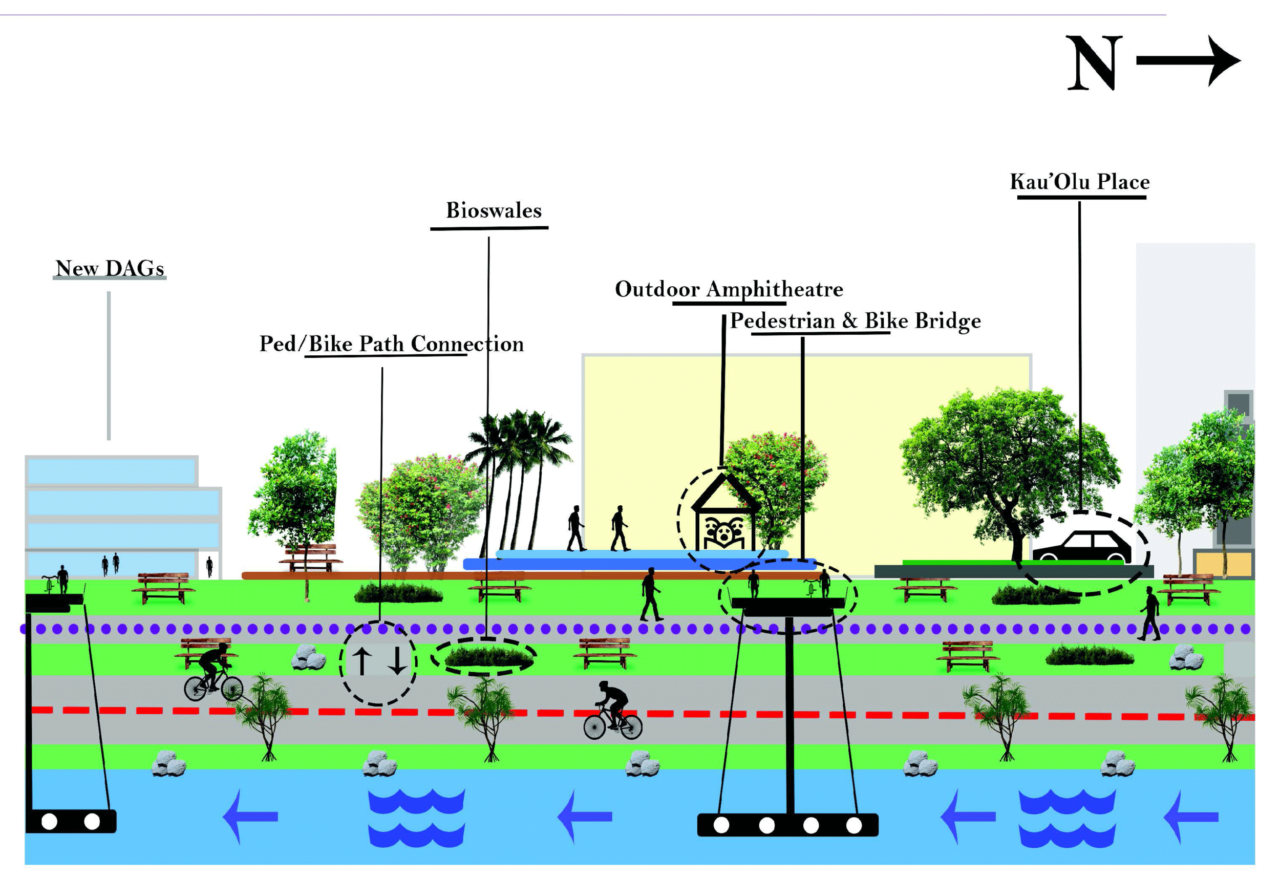
The purpose of this study is to examine flood mitigation design criteria for a new rail transit hub community that is undergoing rapid urban planning and development: the Waipahu Transit Oriented Development (TOD) area on Oahu. The process is a replicable methodology that may be applied to other future developments. This report identifies the extent of anticipated flooding; proposes proof-of-concept level design criteria to mitigate flood damage to roadways and buildings; presents built examples of proposed strategies; and identifies relevant flood design standards and emerging resilience rating systems.
Design Futures Digital Optimization Study
Principal Investigator: Hyoung-June Park PhD, Associate Professor, School of Architecture
Project Staff: Kalani Molina
Student Assistants: Jason Hashimoto

The existing and proposed Transit Oriented Development (TOD) neighborhoods of Waipahu Transit Center Stations and WestLoch in Hawaiʻi are revisited by a proposed computational approach of Urban Network Analysis (UNA). The four measures of UNA: reach, gravity, closeness, and straightness are employed for investigating walkability in these given urban neighborhoods. In each measure, 1) accessibility to transportation, 2) intersections frequency, 3) residential building density, 4) commercial building density, and 5) industrial buildings density are delineated and proposed as vital factors for improving planning and design decisions on walkability patterns around the TOD neighborhoods.
Housing Block Study
Principal Investigator: Cathi Ho Schar FAIA Assistant Professor, School of Architecture
Project Staff: Mark Lombawa
Student Assistants: Shane Matsunaga, Gladys Razos, Ivy Tejada, Sho Tetsutani, Kristyn Yamamotoya

This study synthesizes findings from the DURP faculty partners who provided site planning, ecological hazards study, infrastructure assessment, a community workshop and planning report, and the work on the Waipahu tree canopy and flood mitigation studies, to provide a catalog of housing block typologies that work within the TOD urban and ecological context.
State-led Transit-Oriented Development Design Considerations
Principal Investigator: Cathi Ho Schar FAIA, Assistant Professor School of Architecture
Project Staff: Mark Lombawa, Rebecca Denzer, Nicole Biewenga
Student Assistants: Shane Matsunaga, Gladys Razos, Ivy Tejada, Sho Tetsutani, Kristyn Yamamotoya

The design considerations presented here synthesize the findings from each study into a set of diagrams, sections, close-ups, and case studies that visualize future scenarios. The visualizations do not represent proposed designs, and instead, should be engaged as vignettes that communicate site design, program, and density approaches shown to scale and in context.